Cycling & Shared Pathways
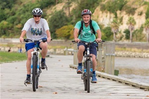
The Whanganui district has long enjoyed a close association with cycling as an active way of getting around, as well as a popular sport and recreation activity.
The district is recognised for its excellent cycling terrain, national accessibility and temperate climate, and Whanganui city is home to mountain bike parks, an inner-city bike park and an outdoor velodrome.
The urban area also offers a great network of walking and cycle paths that run alongside the scenic Whanganui River. Marked cycle lanes connect many suburbs, making it easy to cycle safely from home to school or work. Roads around the city are frequently used by cycling training groups and cycling clubs.
Another big attraction for cycle tourists in the Whanganui district is the Mountains to Sea Ngā Ara Tūhono cycle trail, which is part of the New Zealand Cycle Trail Ngā Haerenga.
Hook turn boxes

We have added green hook turn boxes to the road surfaces at some of our busier intersections.
Hook turn boxes let cyclists turn right more safely because there’s no need to cross in front of traffic travelling in the opposite direction. Making a hook turn is easy – it’s basically a right turn in two steps:
- Keep left as usual as you ride across the intersection to the hook turn box, then turn your bike and wait in the box.
- Next, when the traffic lights change, keep left and ride across the intersection with the traffic.
Cyclists can complete a hook turn at most intersections, even if there is no hook turn box marking.
Check out Christchurch City Council’s video to see a hook turn in action and to find out more.
Shared Pathways
The council is in the process of building a network of future-proofed shared pathways around our city.
A shared pathway is a route designated for shared use by people who are cycling, scootering, skating or walking.
Shared pathways encourage active travel and provide easy direct connections between various parts of our city, from the river to the town centre, to the suburbs.
The council-led Mā Ake Let’s Go programme is a collaboration with key community organisations that aims to make active transportation a popular and safe travel choice for residents and visitors.
This element requires javascript to be enabled.Please wait while we load your map...
Visit the Mā AkeLet's Go Whanganui Facebook page or website to find out more about active transport in our community.
Current works
City to North Mole Shared Pathway
Completed projects
Te Tuaiwi (The Spine)
This three-metre-wide sealed concrete pathway provides a safe route across the Whanganui City Bridge, through town and past some of our central schools.
Te Tuaiwi connects with many of our other pathways throughout the city and gives our children a safer route to school. It also makes it easier and safer for people to get around town on foot, bike, scooter or skateboard, or with mobility aids.
London Street Shared Pathway Stage 1 (southern end of Great North Road)
Construction work is complete on Stage 1 of the London Street Shared Pathway, which is a three-metre-wide concrete shared pathway running from the Splash Centre to Fergusson Street.
This shared pathway makes it easier and safer for children and families to travel to the Splash Centre and the adjacent Springvale Bike Park.
London Street Shared Pathway Stage 2 (northern end of Great North Road)
Construction work is complete on Stage 2 of the London Street Shared Pathway, which is a three-metre-wide concrete shared pathway running from Fergusson Street to Great North Road. This pathway will link to the top end of Te Tuaiwi (The Spine).
Visit the project page for more information.
Planned projects
Whanganui East Shared Pathway - Aramoho to Georgetti Road
The existing footpath between the Aramoho Rail Bridge and Georgetti Road will be upgraded to a three-metre-wide concrete pathway that will run alongside Kowhai Park. This will create a vital circuit between the Whanganui City Bridge and Dublin Street Bridge.
Between the Dublin Street Bridge and Kowhai Park the existing road along the riverbank will be used, with road marking to show the shared pathway. Between Nile Street and Georgetti Road a three-metre-wide section of shared pathway will run along the top of the stop-bank. Construction is scheduled over summer 2020/21.
Tawhero Shared Pathway
This 1.1 km section of three-metre-wide concrete shared pathway will run from London Street to Smithfield Road, down Brooking Street, through the reserve and onto Alma Road where it links to Abbot Street.
This section of pathway is designed to link the suburb of Gonville to the shared pathway circuit.
Springvale Shared Pathway
This section of shared pathway will be put in place after the Fitzherbert Avenue extension through to Mosston Road is completed.
Who pays?
The vast majority of shared pathways funding comes from the New Zealand Transport Agency Waka Kotahi's Urban Cycleways Fund and the government's National Land Transport Fund. The council is providing the balance. We will have to fund the landscape features locally.
Reporting safety issues when cycling
If you encounter an issue with a motor vehicle driver while cycling, you can report it to police using the Community Roadwatch tool on the New Zealand Police website.