Pingao Drive - Fitzherbert Ave to Fox Rd Link Road
- Project typeNew link road
- Project valueApprox. $5M
- Contractor nameDowner NZ
- Completion Date01 December 2026
Image: An aerial view of the proposed link road, with Fitzherbert Avenue on the left and Fox Road on the right
A new 600-metre link road between Fitzherbert Avenue and Fox Road, named Pingao Drive, is being built to unlock land for housing, improve local transport connectivity and support environmental resilience as part of the wider Springvale Structure Plan. The project enables future urban growth while aligning with sustainable design principles.
The link road forms part of a wider integrated catchment management programme. This programme aligns with the values of Te Awa Tupua Act 2017, reflecting a commitment to sustainable development and environmental stewardship.
The project aims to achieve two important strategic objectives.
- Enable residential development for around 600 new housing allotments overall in the Springvale Structure Plan area.
- Re-establish critical ecological linkages and improve stormwater management between Roto Mokoia (Westmere Lake) and the Whanganui River, using water-sensitive urban design approaches.
This project will result in a new road that improves local connectivity, a shared path that supports walking and cycling, and a public reserve that provides both recreational space and ecological value. It will also enable significant residential growth and strengthen stormwater resilience through sustainable design.

Image: An artist's impression of how stormwater may be managed
Project details
The council has worked with a number of private landowners and Iwi/Hapū through a co-design process to ensure the project aligns with both cultural values and urban development goals. The road will be built across currently underdeveloped farmland, with land acquired through agreements with property owners.
Work hours will be Monday to Friday, 7.30am to 6.00pm.
Key components of the project include:
- Road construction
- Cycleway and pedestrian infrastructure
- Climate-adapted stormwater drainage systems
- Environmental restoration of nearby wetlands
- A detailed landscape management plan to guide planting and ecological restoration, including the restoration of native plant communities and reconnection of the Mokoia catchment from Roto Mokoia/Lake Westmere to the Awa (Whanganui River)
Updates
Fortnightly updates are being shared with residents and are available to the community. Check the newsletters below.
Update 28 November 2025(PDF, 4MB)
Update 17 December 2025(PDF, 4MB)
Update 16 January 2026(PDF, 4MB)
Update 13 February 2026(PDF, 5MB)
Update 27 February 2026(PDF, 3MB)
Update 13 March 2026(PDF, 4MB)
Update 27 March 2026(PDF, 3MB)
More images from November 2025.
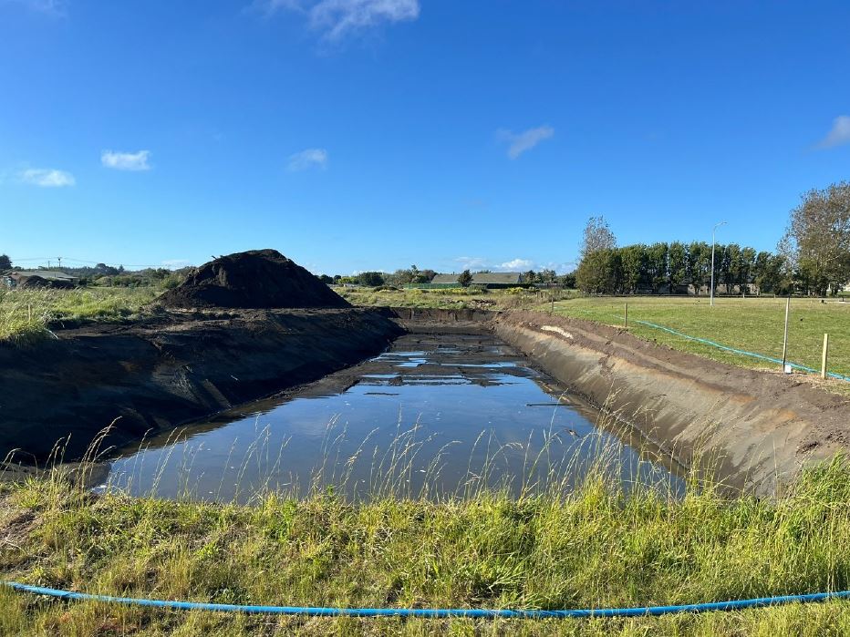
A sediment retention pond
A sediment retention pond is built before any earthworks begin to ensure that runoff from the site is captured and treated. This allows sediment to settle out before the water is discharged to natural waterways.

Construction of stormwater manhole
Construction of stormwater manhole with well point spears located around the manhole to ensure a dry working area

The sediment retention pond
A sediment retention pond is built before any earthworks begin to ensure that runoff from the site is captured and treated. This allows sediment to settle out before the water is discharged to natural waterways
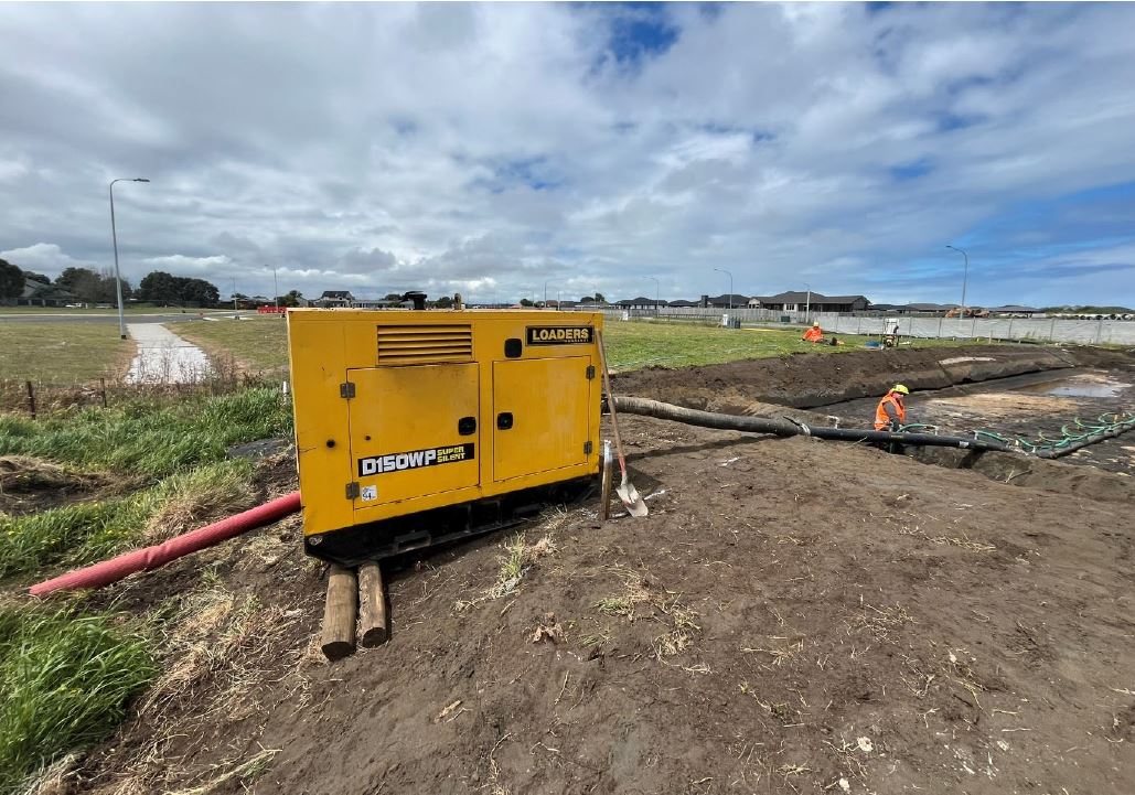
A wellpoint dewatering pump
Wellpoint dewatering pumps are used to help lower the groundwater table and ensure dry trenches for deep excavation. The water is treated through a silt tank before being released back to the natural environment
Benefits and outcomes
- Unlocks land for residential development (up to 600 new homes)
- Enhances transport connectivity and enables walkable neighbourhoods
- Includes infrastructure for active transport (shared cycleways and footpaths)
- Integrates climate-adapted drainage systems and protects local wetlands
- Improves local water quality and reduces flood risk
- Supports ecological connections through comprehensive catchment planning
- Maintains the function of Mosston Road as a key arterial and heavy vehicle route
- Developed in partnership with iwi/hapū, supporting long-term environmental and cultural resilience
The drainage design addresses the area’s low water table and routes stormwater into the Tītoki Wetland via careful engineering and the development of future stormwater reserves.
These swales and systems will filter runoff, improve water quality, and ensure the wetland thrives. A local example of a similar functioning swale system can be seen along Heads Road, west of Rogers Street.

Image: A map showing the link between Roto Mokoia/Westmere Lake, various wetlands, creeks and the Mill Road industrial area
Environmental framework
The road is part of a larger natural catchment beginning at Roto Mokoia (Westmere Lake) and flowing to the Whanganui River, including Mill Road, Tītoki Wetland, Kokohuia Wetland, and Churton Creek (much of which is piped underground). A catchment plan is being developed in collaboration with Iwi/Hapū under the Te Awa Tupua framework to re-establish ecological linkages, enhance stormwater resilience, and improve long-term environmental outcomes.
Te Awa Tupua
The Te Awa Tupua (Whanganui River Claims Settlement) Act was passed in 2017. The act recognises Te Awa Tupua as an indivisible and living whole comprising the Whanganui River from the mountains to the sea, with all its tributaries, physical and metaphysical elements.
The Te Awa Tupua Act
Four values, called Tupua Te Kawa, guide all actions and decision-making to provide for the health and well-being of both the river and its people. The paradigm shift from merely speaking about the river to actively speaking to the river as a community is powered by this new status and the time-honoured values of Tupua Te Kawa.
The kawa are expressed in four overriding principles which shape relationships and interactions with Whanganui River:
Ko te Kawa Tuatahi: Ko te Awa te mātāpuna o te ora
The first principle: The River is the source of spiritual and physical sustenance
Te Awa Tupua is a spiritual and physical entity that supports and sustains both the life and natural resources within the Whanganui River and the health and wellbeing of the iwi, hapū and other communities of the River.
Ko te Kawa Tuarua: E rere kau mai i te Awa nui mai i te Kahui Maunga ki Tangaroa
The second principle: The great River flows from the mountains to the sea
Te Awa Tupua is an indivisible and living whole from the mountains to the sea, incorporating the Whanganui River and all of its physical and metaphysical elements.
Ko te Kawa Tuatoru: Ko au te Awa, ko te Awa ko au
The third principle: I am the River and the River is me
The iwi and hapū of the Whanganui River have an inalienable interconnection with, and responsibility to, Te Awa Tupua and its health and wellbeing.
Ko te Kawa Tuawhā: Ngā manga iti, ngā manga nui e honohono kau ana, ka tupu hei Awa Tupua
The fourth principle: The small and large streams that flow into one another and form one River
Te Awa Tupua is a singular entity comprised of many elements and communities, working collaboratively for the common purpose of the health and well-being of Te Awa Tupua.
Road closures/detours
Please check our public notices for the latest road closures. Much of the work is taking place on undeveloped land. Future updates will confirm any potential impacts on traffic or pedestrian/cycleway access.
Location
Starts at Fitzherbert Ave and runs through to Fox Road, Castlecliff 4501 View Map
-39.9284235,175.0159295
Starts at Fitzherbert Ave and runs through to Fox Road ,
Castlecliff 4501
Starts at Fitzherbert Ave and runs through to Fox Road ,
Castlecliff 4501
Pingao Drive - Fitzherbert Ave to Fox Rd Link Road