Kokohuia/Titoki Wetland development
- Project typeWetland development
- Completion Date30 March 2030
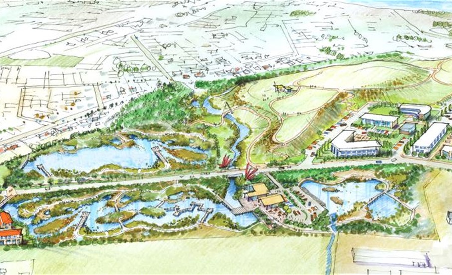
An artist's impression of the completed project
Background
The Kokohuia/Titoki Wetland project was initiated in 2013 in response to the downstream flooding issue at the Heads Road industrial area which suffered a number of damaging flood events with resultant economic impacts on local business. There was a concern that as the Springvale growth area continued to develop there would be an increase in the likelihood of flooding in the Heads Road area.
Being at the lower end of the Kokohuia Stream catchment, the Kokohiua and Titoki wetland system is located in the proposed flood attenuation zone. This will provide robust treatment of stormwater runoff prior to discharge into the tidal reaches of the Whanganui River.
It was realised early on that an integrated wetland design could also improve additional significant values beyond flood management such as ecological connections, biodiversity enhancement, community recreational amenity, stronger walking and cycling connections to the river, education and economic benefits.
The restoration of the historic kokohuia wetland would restore mana to the whenua and community and as such would be an important project for tangata whenua. The council started working with Hapū members, a landscape architect, hydrologist, council officers and Horizons Regional Council officers to develop an integrated plan that enhances flood control through low-impact design in the form of wetlands at Kokohuia and Titoki, and swales along Heads Road.
Balgownie Landfill
One of the major challenges with the master plan was to manage historical and outgoing impacts of the landfill on the Kokohuia site.
Balgownie Landfill, located next to the Kokohuia Wetland, ceased in May 2000 and final capping was completed in March 2001. Some of the perimeter areas of the site are now being leased for commercial and farming use. Some of these areas are being used to store materials including concrete, green waste, steel, car bodies etc.
The landfill and current land uses had an impact on how the land was perceived by the community and on the environment with open leachate drains and rubbish becoming exposed on the landfill edges during rain events. The site had been fenced off from the community for decades.
Developing the master plan
Through a series of workshops in 2012, 2013 and then July 2021 an integrated master plan for Kokohuia was developed that included the following:
1. Increasing the area of the existing wetland and creating new wetlands where the land had not been impacted by the landfill to increase stormwater retention and ecological values.
2. Developing a range of walkways and cycleway through the site connecting the community north of Kokohuia to the river, Kokohuia School, and employment in the Heads Road area. This also allows for a connection to the existing mountain to the sea cycleway on the river stop bank.
3. It suggested an ecological connection from the river to Kokohuia wetland to the proposed Titoki wetland beyond.
4. The wetland and landscape planting was to focus on biodiversity values that would support native terrestrial fauna.
5. A wetland centre was also suggested in the centre of the proposed wetlands to provide educational and research opportunities for local schools as well as national. The centre also provided an economic opportunity that would support the ongoing funding of the wetland development.
6. A series of walkways and educational interpretation was suggested around the wetland edges for the public to engage with.
7. The landfill cap would become a passive recreation space, and place for art and to view the mountain while providing the communities high ground in case of a tsunami
Te Awa Tupua Settlement Act
In 2019 the Te Awa Tupua Settlement Act came into effect and the 2021 workshop used the Act's values - Tupua te kawa, to inform the master planning process. The act itself is an international first and provides an Indigenous framework to inform wetland development which is also an international first.
Whanganui has a significant opportunity to lead the way in demonstrating how integrated low impact stormwater management can occur within an indigenous framework and will be setting a precedent globally for future development and income opportunities.
Both the 2013 and 2021 workshop and master planning process came to similar conclusions because the site conditionals, especially the water flows, springs and landfill really impact on the possible master planning responses.
The master plans have been tested against flooding modelling that was created in 2015-2017. The modelling has shown that the Kokohuia wetland development had a positive impact on reducing flooding in the Heads Road area and created significant stormwater retention capacity.
This project has had a significant impact in how the council approaches stormwater catchment and water. Hapū has been involved in the workshops and co-master planning process since 2012. That has strengthened existing relationships and developed a working methodology which has flown onto other stormwater and stream restoration projects around the Whanganui River urban catchment.
Hapū in place are involved with water-based master planning and restoration such as the Titoki wetland development, Aramoho River edge master planning, Pūtiki community resiliency planning, the Awarua stream landscape concept and many other projects around the city and beyond.
Mokoia Catchment Rōpu
The Mokoia Catchment Rōpu is a collaborative collective of Whanganui and Ngā Rauru Kītahi Hapū, community and stakeholders (Whanganui District Council Infrastructure, technical advisors, Nga Tangata Tiaki o Whanganui, Te Mata Puau) forming a representative advisory and working group for the Kokohuia and Titoki Wetland development.
The MCR’s kaupapa is to provide guardianship and maintain cultural preservation for all water management activities and decisions related to the lakes, waterways, tributaries, streams and repo within its rohe that extends from Rotomokoia (Westmere Lake), down through the western Whanganui urban catchment area to the Awa and Moana.
MCR is guided by the Hapū and the community they represent and in accordance with Te Awa Tupua Settlement Act 2017 and Tupua te Kawa, that embodies the enduring inseparability and ancestral connection of ngā tangata to the Awa, and the intertwined destiny and shared responsibility to ensure the health and wellbeing of the Awa, its life blood (all waterways/bodies) and thus ngā tangata, for generations to come.
The MCR was officially formed in December 2023 after a Hapū Wananga and presentation when all uri of Whanganui and Ngā Rauru Kītahi Hapū were invited to attend. The Hapū Wananga and presentation was to provide those hapū an overview of the proposed Kokohuia and Titoki wetland development and its progress to date.
The Wananga was also an opportunity to present the outcomes, visions and aspirations of the collective hapū, community, and stakeholders, from the July 2021 and 2012/13, wananga and workshops, that had been delayed due to Covid 19. More importantly, it was to seek endorsement from those hapū to recommence the planning for the development work, and to formally invite those uri interested to be part of the MCR to lead the development process with the council and other stakeholders.
The MCR has been meeting monthly with council Infrastructure representatives, and technical advisors, to plan the activities of the integrated master plan as highlighted in points 1-7 to achieve positive water and community outcomes in accordance with the cultural values and principles of Te Awa Tupua Settlement Act 2017 and Tupua te Kawa.
Although the MCR fully supports the positive, ecological, recreational, water quality and flood management outcomes the Kokohuia/Titoki Development will provide, of greater importance will be the achievement of our collective Hapū cultural aspirations and vision for the repo.
Hapū vision and aspirations
Te Repo o Kokohuia, and the interconnected wetland system extending to the Titoki Street Repo is an area of great historical significance to Whanganui and Ngā Rauru Kītahi Iwi. Once a thriving wetland that provided mahinga kai (plant, aquatic and native bird life) food gathering sites, resource materials (harakeke) and rongoa (medicinal plants) for whānau, marae and Hapū that traditionally lived there.
As a result of urban development over the years much of the wetland has been destroyed and degraded and connection to the Awa cut off.
Our collective Hapū have made it very clear what our vision and aspirations for the development are:
- Ecological reconnection of the repo to the Awa (to create a native freshwater fish spawning habitat)
- Upgrade of the leachate management from landfill to ensure no contamination of the current and new wetland (ongoing water and soil testing)
- Comprehensive water quality management measures to be implemented for all water into the Kokohuia and Titoki repo.
- Revitalisation of the current wetland and expansion as proposed in the integrated masterplan.
- Greater community connectivity, recreational and educational amenities to provide the history and cultural significance of the repo to both Whanganui and Ngā Rauru Kitahi Iwi and Hapū.
Next steps
This project is guided under Te Heke Ngahuru with the Mokoia Catchment Rōpu, a collective of iwi and hapū, Whanganui District Council and technical advisors. The next steps for the wetland development project include re-engaging with the community and investigating public funding sources based on international interest in this work under Te Awa Tupua legislation.
Healthy Streams Whanganui
This project is also part of Healthy Streams Whanganui, which is a community project led by Whanganui District Council to keep our waterways clean and tidy. Community project partners include local iwi, Horizons Regional Council, government departments, charitable trusts, commercial businesses and landowners.
You can read more about Health Streams Whanganui here.
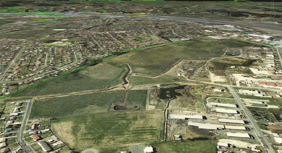
A 'before' view of the Kokohuia Wetland area
Location
Kokohuia wetland, Castlecliff 4501 View Map
-39.9426808,175.0050375
Kokohuia wetland ,
Castlecliff 4501
Kokohuia wetland ,
Castlecliff 4501
Kokohuia/Titoki Wetland development